Showing posts with label lobster trap tags. Show all posts

Monday, May 6, 2013

Curtis Cove Report - Apr 8, 2013

Wow. Way too far behind now. Time to make a few brief posts to catch back up if I can! Monday, April 8. 1:15PM. Three hrs past high-tide. Strong seabreeze, low 50s. Bright sun, a beautiful day to be here.
The beach was still healing itself nicely after winter's violence, getting its old shape back. On this day I found great natural sorting -- a tight layer of wrack & pushed-up plastics at the back of the foreshore; beautiful rippling and sand on the low foreshore.
All the wrack was very old & pulverized. Not a lot of new energy this week. Though at least one wave brought something interesting:
Took a wrong turn at Albuquerque
Normally, this would be the kind of day with very limited finds. But, this is Curtis Cove. And the beach's healing process included releasing more of the pent-up plastic from winter's storms. As the seaweed rots & disintegrates, ever more plastic gets left high and dry.
211 pcs of rope, about 250 ft
289 pcs of nonrope debris
500 finds:
  • Bldg material/furniture: 0
  • Foam/styrofoam: 0
  • Fishing rope/net: 211
  • Fishing misc.: 230 (188 vinyl scraps, 4 bait bags, 3 vents, 2 trap tags, 2 bumpers, 5 various trap parts, 1 glove, 25 claw bands)
  • Food-related plastics: 16 (2 bottles, 1 bottle half, scrap bottlecap, 1 whole cup, 11 cup scraps)
  • Food-related glass/metal: 5 (4 aluminum can scraps, bottle cap)
  • Nonfood/unknown plastics: 18 (4 upholstery pcs, duct tape, 2 washers/spacers, bead, warning tag, caulk strip, 2 plant tags, cigarette lighter, bag scrap, mylar balloon scrap, latex balloon, bandaid scrap, toy taxi)
  • Scrap plastics: 14 ( 8 > 1" , 6 < 1" )
  • Paper/wood: 0
  • Non-plastic misc./unique: 6 (3 fabric scraps (1 large), 3 gloves)
Wow, 500 on the dot! I promise I didn't plan that.

A varied week. "Only" 188 vinyl lobster trap scraps, a step in the right direction. But a really eclectic week. Of course lobster fishing heavily dominated. But a big slice of modern life was represented. A couple stand-outs:
Warning tags aren't paper anymore; they're plastic fiber. Surprise, surprise.

And of course I found still more of these plant ID stakes:
As I'm now clearing out our condo's community garden, it's easy to see why so many of these stakes get into the ocean. I'm finding many years' worth in the overgrowth. A good rainstorm can easily tumble them into the drainage gulley, and from there, straight out to the Deep Blue. :/

Running Year 2 YTD counts:
  • Total pcs of litter -- 2758
  • Pcs fishing rope -- 723
  • Vinyl lobster-trap scraps -- 1551

Sunday, January 29, 2012

Transatlantic Connections - Part I: Lobster Trap Tags

After nearly two years, there's plenty I'm still learning. But one thing is sure. The same oceans that divide us, connect us. In the Pacific, the currents tie East to West and West to East. The Atlantic, thanks to the Gulf Stream, is more of a one-way street, North America ---> Europe.

Plastics from my part of the world can make the 3,000-mile crossing unscathed, washing up on Irish & British shores. Many bear marks that identify what they were, where they came from, and even when. Each is a time capsule and a fabulous source of information, and stories. If one knows what to look for!

So here's the first in a series of pages dedicated to long-distance plastic debris. Stuff that could start in the Gulf of Maine, wash up on an Irish or British beach, and be found.

Lobster Trap Tags

Gulf of Maine lobster trap tags are a common find on beaches in Maine. And, it turns out, far from Maine. Lobstering is an enormous & highly regulated local industry. By law, all lobster traps must have one of these colorful little strips attached to it.
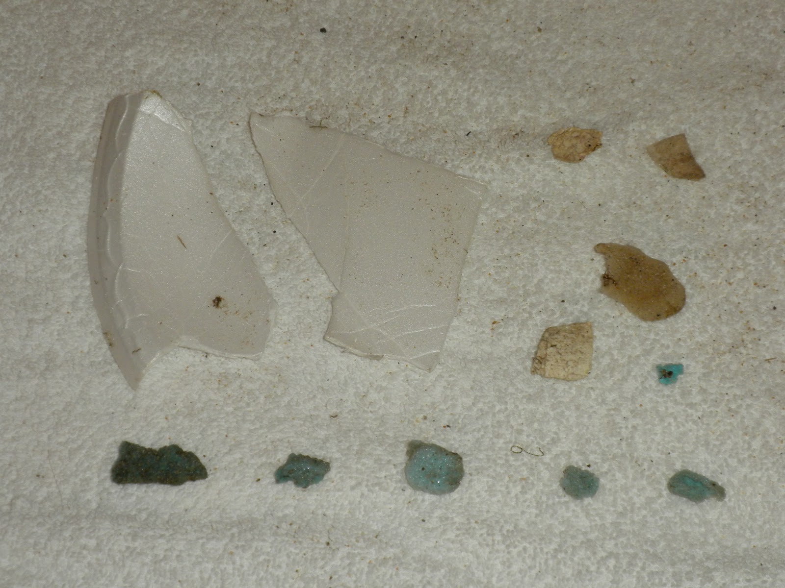
Trap tags are color-coded by year. The tags above are the colors used in Maine from 1997 (top) through 2010 (bottom).

Each tag is stamped with owner's license, federal fishing zone, trap #, state/province, year, and region. So, for example, the green one is 6841 A1 0789 ME 09 Z:G EEZ. 6841 is the owner's license; A1 is the national region (basically coastal Maine); 0789 is the trap number; ME 09 is Maine 2009 season; Z:G is Maine's "G" zone (the most southwesterly; with A being the most northeasterly); and EEZ meaning the trap can be set out in deeper water several miles offshore.

(Tags from other states & Canada use varied color schemes. Also, Maine has some anomalies. The bottom tag says "NC," which means non-commercial -- this is a recreational fisherman who's allowed to have only 5 pots in the water at one time.)

In season, there can be several million lobster traps in the water. Tags break free from traps all the time. They're buoyant, and many find & ride the Gulf Stream to Ireland and the UK. Rik Bennett was combing his beach in Wales in 2010 when he stumbled upon this one:
Not bad for 3 years at sea
More recently, Andy Goodall from Newquay, Cornwall, UK discovered this Newfoundland, Canada specimen in December 2011:
Stunning shape for maybe 12 years at sea!
And last but not least, an amazing story of connections across 3,000 miles and 20 years. Rosemary Hill lives Waterville, County Kerry, Ireland. Walking the beach last year, she stumbled upon a tag. Not the colorful annual band, but a separate permanent tag that IDs the owner more thoroughly.
On a hunch, she decided to see if she could find the owner. And she did, through his son's FaceBook page. This tag, belonging to a Massachusetts fisherman, was on a trap lost in the "Perfect Storm" of 1991! After an incredible journey, it washed up on Irish shores. And a transatlantic connection was formed, reported in both European and American newspapers.

Plastic is forever. And that's bad news. But if it's out there in the ocean already, and it has stories to tell, isn't it nice to be able to tell them? Keep your eyes open; you never know what you may find!

Monday, December 13, 2010

Look What the Current Dragged In, Part II

Back in August I wrote a little piece on a curious lobster trap tag that had floated in on the tide. With help from the good folks at the Gulf of Maine Lobster Foundation, I learned that the tag had taken a 200-mile journey from Canada.

Since then, I've recovered many "Wild Canada" claw bands, as well as half of a recycling bin from New Brunswick. The reason for all this Canadian flotsam is simple. Coastal Maine is fed by the Labrador Current, an ice-cold flow that originates on the western side of Greenland, arcs past eastern Canada, and washes down through the Gulf of Maine.

So it's little surprise that Canadian litter reaches Saco's shores. It's also little surprise that, given the complexity of the Gulf of Maine, things sometimes go a bit wacky.
from http://www.nefsc.noaa.gov/publications/
crd/crd0807/images/f8.gif
Occasionally, a Flotsam Diarist stumbles upon the coolest resources to help learn about the world. Take Environmental Monitors on Lobster Traps, an ingenious collaboration between local researchers, universities, and fishermen. Together, they collect live data on surface currents by launching dozens of drifters with GPS transmitters. Here's a good one that was tracked for several months just this summer:
Released May 8 near Portland, ME
Died Sept. 4, Georges Bank, 150 mi E of Cape Cod
Victim of Hurricane Earl
As the eMOLT track above shows, not everything that flows from the north ends up at Bay View beach. Wind & current may just as easily pull it southeast. If so, it can get caught in one of the Gulf of Maine's many small gyres -- vortexes of swirling waters. There, a piece of flotsam may be trapped for years, and eventually flung out in most any direction. (In larger gyres like the infamous Great Pacific Garbage Patch, millions of scraps of plastic debris churn endlessly in a toxic soup. There are five such gyres of swirling trash now recorded in the world's oceans; there is no known way to effectively clean them up.)

So what happens if a piece of Maine or Canada flotsam gets dragged farther and farther southeast?

Take the example of this little guy:
Just an average Maine lobster trap tag
Sometime after 2007, this tag broke free from its trap, and rose to the surface. Bobbing on the waves in the Gulf of Maine, it stumbled into a gyre or two. Mother Nature eventually cast it southeastward. One fateful day, it met the famous Gulf Stream.

The Gulf Stream gets its start in the tropical waters of the Caribbean and southern Florida. It flows northward along the eastern U.S., veering eastward south of Long Island, NY. It rides south of Cape Cod, warming the shorelines of southern New England on its way.* Eventually its tropically-toasted waters cross the entire Atlantic and flow past the UK and Ireland. These isles, even though they lie nearly 10° farther north than Maine, are made temperate by waters originally heated thousands of miles away.

That little red lobster trap tag, still in nearly perfect condition? Found here:
Gower, South Wales, UK
(image snapped from Google Earth)
In early November 2010, beachcomber Rik Bennett was wandering his local shores in southwest Wales, when he came across this tag. Curious, he scanned the Web to see if he could learn anything about it. Eventually, his search brought him to The Flotsam Diaries. And brought this tag's 3,500 mile journey to light!

A wonderful and poignant reminder that the world is a small place. Everything connects, somehow, with everything else. And water -- the ocean -- is the constant. If you treat your part of it well, it will remember. If you treat your part of it badly, it will remember.
from www.oceanmotion.org - another priceless resource
for a budding Flotsam Diarist


* The warm Gulf Stream waters never reach Maine. All we get is the Labrador -- which is why Maine's ocean temperatures rarely break 60 degrees F, even in August. Actually, Saco Bay records the warmest ocean temps in Maine, being fed by the major Saco River, which is heated by the sun as it travels its 134-mile course.

Thursday, November 18, 2010

Collection Report Nov 4-11, 2010

So early November was a tricky one for a Flotsam Diarist. Fun fact: Novembers in Maine are kind of cold, windy, dreary, and rainy! I tried to hit the beach on Nov 4, but the wind and rain chased me off after only a few minutes. All I accomplished was a quick scan of the high-tide line for the obvious bits.

I managed to get out for a few more minutes on Nov 7. As you can see, nature had been busy scouring the sands.
The cleanest of slates
My daughter came along too, carrying her own special bit of flotsam - her new favorite yellow shovel, rescued from the beach in August.
Flotsam Diarist 2.0 beta
As the attire shows, November 7 also wasn't an ideal collection day. Plus, a 3-year-old doesn't really have that kind of patience. So on to November 8. Which started interestingly enough:
Ooh, little bit of rope
Or not so little
You just never know
And after this moment, what would happen? Yes. More rain.

But finally, November 10 was... well, it was cloudy, 41 degrees, and insanely windy. But for an hour, it actually wasn't raining. So I finally got in the full walk.
The proof is in the footprints; all mine (OK, except the dog's)
So this is a slightly unorthodox collection report, from a slightly unorthodox two weeks. Here's Zone N.
67 finds:

  • Building materials: 8 (7 slats, one post end)
  • Foam/Styrofoam: 12
  • Fishing misc.: 10 (2 buoy bits, 1 lobster trap entry net, 4 rope scraps, 2 long bits of twine, 1 shotgun shell wadding)
  • Food-related plastics: 8 (inc. banged-up coffee lid scrap and very eroded plastic/foil scrap)
  • Food-related metal/glass: 5 (1 can, 1 can scrap, 3 bits of sea glass)
  • Non-food/unknown plastics: 15 (inc. shovel, hard solid plastic rod/fitting, balloon scrap, 5 bits of plastic bags, central webbing from bandaid
  • Cigarette filters/plastics: 4 (3 locals + 1 floater)
  • Paper/wood: 3 (1 swiffer cloth, 1 dryer sheet, 1 Dubble Bubble wrapper)
  • Misc./unique: 2 (Buzz Lightyear balloon, golf tee)

Some usual suspects. And one not so usual.
To Infinity and...
This collection's biggest haul by mass was fishing gear.
Wish I had the whole buoy #
Here's a closeup of that contraption (part of a lobster trap, it turns out) that was mostly buried in the sand:
Not part of a Lady Gaga costume
And my current nemesis, styrofoam:
Same colors show up week after week 
Unlike last week, Zone S didn't produce much of note, except an abraded lobster trap tag from 1999.
25 finds:
  • Building materials: 5 (asphalt chunk, 4 fence slats)
  • Foam/Styrofoam: 5
  • Fishing misc.: 4 (3 bits of rope, 1 trap tag)
  • Food-related plastics: 0
  • Food-related metal/glass: 2
  • Non-food/unknown plastics: 7
  • Cigarette filters/plastics: 2 (1 local, 1 floater)
  • Paper/wood: 0
  • Misc./unique: 0

All in all, the finds are still across the spectrum, and are still coming from local drops, blow-ins, and wash-ins. (The latter two more than the former now, which makes sense.) And the cigarette count remains utterly collapsed -- a welcome sign, but one that's making me rethink some of my assumptions.

This was a period of biting wind, drizzling -- sometimes pouring -- rain, and shifting sand. The slope of the beach is changing, but in ways I wasn't quite expecting. Close to the water, it's eroding fast. But close to the dunes, new sand has been dumped. The beach is becoming steeper, and every week the contours change. As shown by the lobster trap/rope, the surprises are there. Just biding their time. What will the next report bring?

Friday, October 15, 2010

The Winds of Autumn, Oct 7, 2010

October 6 brought the first real taste of the Maine winter to come. Cold winds whipped and gusted and tossed trees around for hours. Sheets of blinding rain blew horizontally well into the night. October 7 was still gray, blustery, and threatening for much of the day. The last spits of drizzle only finally ended right about the moment I pulled into the little parking lot at Bay View in the early afternoon. I had a hunch what this might mean.
Kelp thrown ever higher up the beach
The evidence of Mother Nature's little shindig wasn't hard to find. The kelp was almost up to the dunegrass. Shattered and mangled debris spread up and down the coast -- including score on score of these faded wooden slats, ripped from the dune fencing nearby:
From Zone N...
...to Zone S and beyond
Actually, not scores. Hundreds. 237 individual slats or slat-shards, to be exact. Who knows how many more littered the areas outside my collection zones.

But, as usual, all debris is not local. One piece in particular had traveled a very long way to join the party.
Half of a recycling bin
A well-traveled recycling bin!
St. George, N.B. (New Brunswick) is over 200 miles to the north. I have an e-mail in to Jail Island Salmon to see if, on the off chance, they remember when they lost a bin. One wonders where the rest of it is.

Though possibly the longest-traveled, the bin was hardly the only eyebrow-raiser. In fact, as the tide receded I got a chance to witness the waves offer up another goodie.
Dear "1761 0057 01 Z:G,"
I found your trap
But it was in Zone S that I stumbled upon the piece de resistance...
Half of a Zodiac XDC inflatable
You never really want to find half of a boat washed up on your beach. Its serial # was still intact (CG508, built May 1985), so I gave the info to the police. There were no personal effects, and plenty of non-tragic explanations. But still...

Things I sadly didn't get pictures of in situ included one complete and two fragmentary lobster trap buoys, cast all the way up to the edge of the dune grass. (There will be pics of them in the forthcoming collection report.) As well as a remarkable amount of styrofoam scraps. And the usual cigarette butts, etc.

Not to mention all the things that were lost back to the sea before I even got there, thanks to a brisk offshore breeze.
Blown from the dunes back to the water's edge... and beyond
All told, a very busy day. Full report following soon. But for now, I'll close with a little uplift.
Wind art
I collect, catalog, and blog about the detritus of human life not because I think I can make the world beautiful. But because it is beautiful.

Thursday, September 16, 2010

Collection Report Sept 4, 2010

Following on from this post about the scene at Bay View beach, Saco, Maine the morning after former-hurricane Earl barely missed us.

I knew when I got home I had a big haul. Both from the flotsam washing up right in front of my eyes and the remnants of late-summer fiestas.
42 individual sparklers... not that I counted
Overall, it was an astounding catch. Here's Zone N:
411 finds:
  • Building material: 0
  • Foam/Styrofoam: 12 (inc. two pieces of Dunkin Donuts coffee cup)
  • Fishing misc.: 12 (4 claw bands, 5 pieces of rope, 2 trap tags, 1 trap tag scrap)
  • Food-related plastics: 59 (inc. Ritz PB crackers, Quaker Chewy oatmeal bar, Sunbelt Choc Chip cookies, Twizzlers, Reese's PB cup, Snickers bar, organic vanilla yogurt, label from Granny Smith apple, label from Fuji apple)
  • Food-related metal/glass: 12 (inc. 5 bottle caps: Mike's Hard Lemonade, Twisted Tea, Miller Lite, and 2 Blue Moon Brewing Co.)
  • Non-food/unknown plastics: 70 (inc. bits of plastic shopping bags, 4 bandaids, rabbit-shaped Silly Band, insole (?) labeled "RIVER", 4 rubber bands (maybe from sandwiches), beach umbrella base, "leaf" from toy or ornament, and 15 bashed-around scraps of hard plastic -- most likely washed in)
  • Cigarette filters/plastics: 168 (152 local, 10 likely floaters, 6 plastics)
  • Paper/wood: 26 (inc. burned Spanish-language magazine bits found at bonfire, label from plastic water bottle, Budweiser label scrap, pharmacy receipt, Reny's "Paid" sticker, two salt packets, ice-cream cone wrapper)
  • Misc./unique: 52 (inc. 42 sparklers, sock, towel tag, velcro scrap, 4 firework scraps, nylon seam reinforcement strip)
Just... wow. 411 finds shatters the Zone N record. It shatters the combined N/S record. 162 cigarettes shatters that record. The bashed-up, washed-in plastic scraps are sobering, the trap tags and claw bands ever-present after any storm. The food wrappers in their bright, happy colors...

Of all the bits & bobs, a few that caught my eye:
What "162 cigarette butts" looks like
Shards of mostly waterborne plastics
Two of the ~1 million tags lost annually
Nope, burning plastic still doesn't get rid of it
Which claw band's been in the water the longest?
Needs no caption
It just keeps coming.

By the time I'd finally finished picking up Zone N, there was again no time to check Zone S. And other commitments kept me away for the days afterward. So again, sadly no comparison between "busy" Zone N and "quiet" Zone S. But this coming weekend an old friend I haven't seen in a very long time will be visiting with me. And for some strange reason, he also thinks a nice way to spend a Saturday morning is picking up other folks' trash at the beach! So we just might have a Zone N-and-S post again soon.

Sunday, August 15, 2010

Look What the Current Dragged In, Part I

As always, the finds that are the most fun are the ones that get you asking questions.

On an early trip to Bay View, back in June, I uncovered this...
...which looked vaguely like a lobster trap tag. (Probably the word LOBSTER put that thought in my head.) But this was totally different from the ones I was used to, issued by the State of Maine:
In fact, it was printed in English & French. Could this be a Canadian tag? This far south?

A quick Google search proved that "DFO" is Canada's Department of Fisheries and Oceans. But could the tag have been from a U.S. boat that had permission to fish in Canadian waters? I asked the good folks at the Gulf of Maine Lobster Foundation. And they confirmed that a Canadian tag could only be issued to a Canadian fishing boat. The farthest south that this lobster trap could have been set would have been shared waters off Machiasport (far Down-East Maine).

So this little white lobster trap tag really had traveled south along Maine's coast for some 200 (or more) miles, eventually coming ashore at Bay View Beach, Saco. And into my black garbage bag, where it now lives in my condo's basement.

Which is pretty flippin' cool.

But wait... All I've ever heard of currents is "Gulf Stream" -- the current that starts far down south and travels north up the eastern seaboard. So how did this tag travel south for some 200 miles?

If I wanted to know about what was winding up on my beach, maybe I should figure out how things floated in the ocean.

Here's a shocker: Turns out, the ocean is a complicated place.
from www.oceanmotion.org/html/resources/oscar.htm
More to follow.